

Registered Professional
Land Surveying
Licensed professional Land Surveyor in Central Georgia and South Metro Atlanta.
Contact usExperienced Professional
Integrity & Honesty
Technical Expertise
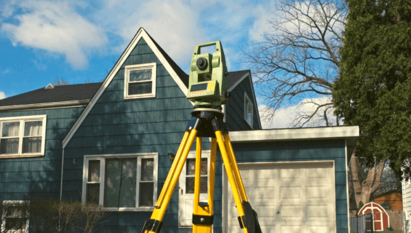
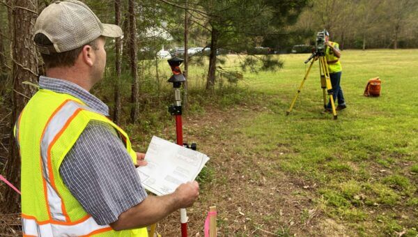
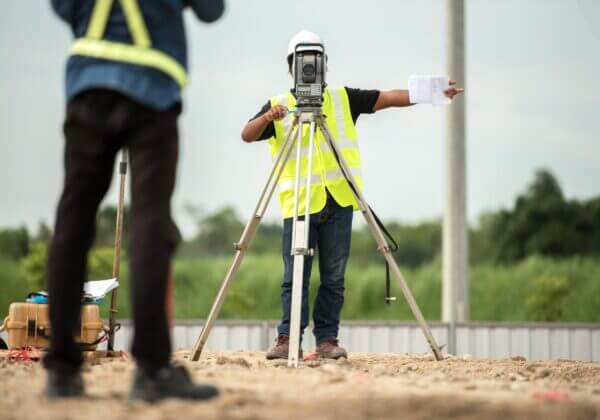
Registered Professional Land Surveying services
Surveying Pike County
and surrounding area
Registered Professional Land Surveyor in the South Atlanta and Middle Georgia area, including Pike County, Spalding County, Lamar County, Upson County, Butts County, Henry County, Fayette County, Meriwether County, Coweta County, Zebulon, Barnesville, Griffin, Hampton, Fayetteville, Peachtree City, Thomaston, and more.
Our Services
Land Surveying services
in Middle Georgia and South Atlanta
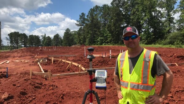
Construction Staking
Construction Staking. also known as Construction Layout or Site Layout Survey, is the process... Read More
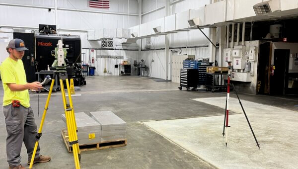
As-Builts
An As-Built Survey is used to locate construction improvements. Local or state zoning boards ... Read More
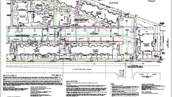
ALTA/NSPS Land Title Surveys
If you desire to understand the benefits of a Land Title Survey, you must research the tenure... Read More
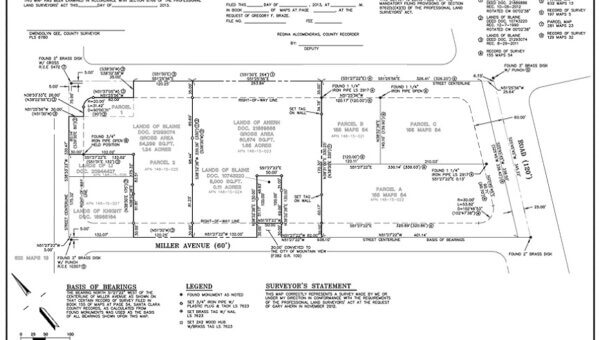
Boundary Surveys
Boundary Surveys locate and note the parameters of a parcel. Boundary surveys find existing p... Read More
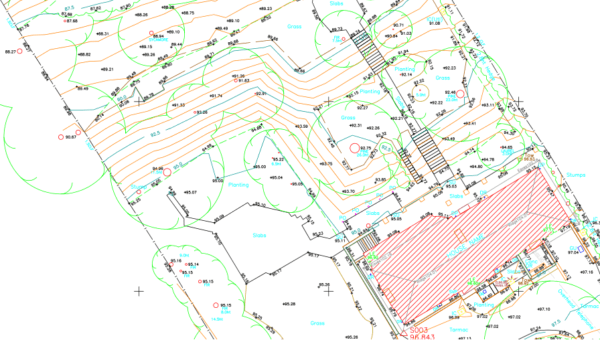
Topographic Surveys
Topographic Surveys or Contour Surveys are used to establish elevations on the parcel. They m... Read More
FEMA-Flood Elevation Certificates
A flood elevation certificate is a document required for properly classifying properties that... Read More
Property Line Staking
Property Line Staking is often required to build a fence, outbuilding, or other improvements.... Read More
About Terra Services
Terra Services Co., LLC is headed by Randy Davis.
- Georgia Registered Professional Land Surveyor #3448
- Graduate of Middle Georgia College
- SAMSOG (Surveying and Mapping Society of Georgia) member
- 20 years experience including 6 years in the utility right-of-way industry
- A wide range of experience ranging from rural boundary surveys, road construction, column line layout for mid-rise structures in Atlanta.
Contact us now for your next project!
Randy Davis
Owner/PLS 3448

Want to Know More?
770-468-9838

Recent Posts
Latest News & Blog


Contact us
Have an inquiry?
770-468-9838
.
Contact Us
Only a Professional Land Surveyor licensed in the State of Georgia can tell you where a property line is. Land Surveyors utilize legal recorded documents to calculate and determine property lines with accuracy. The only person who can tell you where your property line is, is a professional licensed land surveyor.
Possibly. Old, ancient (established) fence can be a good indicator of boundary lines but should not be assumed to be the line. Neither you or I were there when the fence was installed so the only way to tell where the actual line is, is to survey and measure the line and compare the measurement between corner monuments to the existing records (deeds and plats). I have seen old barbed wire fence as much as 50 feet off of the line.
I/we are performing a professional service on your most valuable possession – your house and land. And unlike other investments to your property such as new vinyl siding, new floors, a deck built on the back of your house, a survey delineating boundary lines is a one and done cost if you preserve the survey markings and monuments.
Most people only see the survey crew come out and put stakes in the ground and are unaware of the preparation of the field work. The first part and most important part of a survey is the records research. Research is done not only on your property but also the surrounding properties to look for overlaps or gaps in ownership. The records (deeds and plats) are carefully evaluated and compiled and then field measurements and compared to the records. My goal is not to be cheap. My goal is to give you the best Survey possible at a competitive price.
In addition to the field work, we have equipment to pay for, insurance on equipment, insurance of vehicles, and cost of materials to pay for.
The expensive equipment you see is only taking the measurements. The ability to think and rationalize through a problem and discrepancy is what sets Professional Land Surveyors apart.
Not every individual may require the direct services of a Professional Surveyor during their lifetime, but everyone benefits from the services of Professional Surveyors in some way.
If you walk down the street, drive on a highway, take off or land at an airport, enjoy a boat ride on the lake, ride a train across the countryside, take your children to the neighborhood park, or ride/walk on public trail that activity has been in some way facilitated by the work of a Professional Surveyor.
If you are a seller or potential purchaser of a home or property; a title attorney; loan officer; real estate agent; or real estate attorney you rely on the expertise of a Professional Surveyor who has established, or will at some point establish or identify, the location of property boundary markers, and whether there are potential issues, such as whether, and to what extent, the property lies near or within a designated flood zone. Simply stated, the Professional Surveyor provides for purchaser’s peaceful occupation of the land.
If there are features (driveways, fences, buildings, plants/trees, plots of timber, recreational amenities such as pools, etc.) on land you own, or on property you intend to purchase, only a Professional Surveyor can officially determine whether those features lie partially, or completely, on that property.
If you are a developer, architect, engineer, or other professional involved in the division or development of land, you will require the services of a Professional Surveyor in any number of ways. Those can include a boundary survey; a topographic survey; construction layout survey; the location of potential impediments to development such as flood zones, wetlands, physical boundary-line encroachments, easements, accessways, etc. The Professional Surveyor does not always determine whether these impediments exist, but is the one who is responsible (generally by law) to identify their location relative to the property’s boundary lines, and to other features on the land. Although not all Professional Surveyors possess the expertise to identify the above mentioned issues, many do, so it is important to inquire whether the Professional Surveyor will both identify and locate them, or will locate them based on identification by some other expert.
Generally speaking, among the variety of professional services providers, the Professional Surveyor is the only one that is likely to be involved in a project from beginning to end. He/she is the first on the property to verify its boundaries and acreage; the one to provide official maps/plats utilized to purchase or identify the useable space for any intended purpose, and to create official plats for any division of the land; the one to provide reference points for the construction of streets, utilities, buildings, etc.; the one to confirm that features constructed on the site are located in the correct horizontal and vertical location, and thus ready for use.
Whether you realize it or not, your life is affected every day by the expertise, dedication, and skills of a Professional Surveyor.